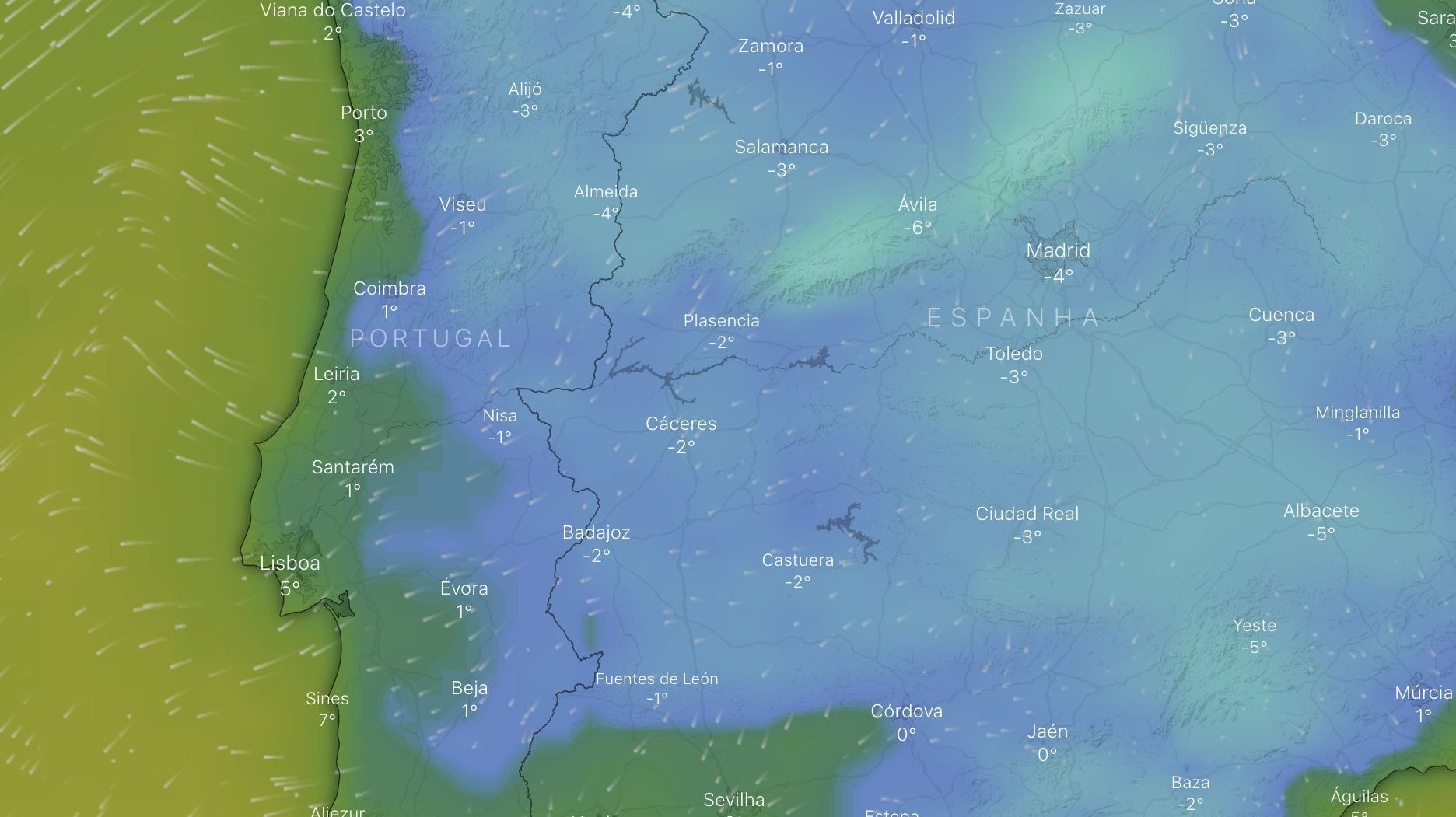
The worst is yet to come. If the cold has returned these days and keeps, until mid-afternoon this Saturday, half of the country —11 districts, from Leiria onwards— in yellow alert due to snow, not only will the rest of the weekend be even colder, As of Monday, a new mass of cold air, now coming from the continent, will accentuate the low temperatures in the interior, especially at night.
The warnings for this intense cold are already on the IPMA map and are in effect from this Friday at 6:00 p.m., extending, for the moment, until Monday at 3:00 p.m. Portalegre, Castelo Branco, Guarda, Viseu, Aveiro, Bragança and Vila Real These are the seven districts that are already on yellow alert due to low temperatures. The minimums drop on Sunday, the maximums on Monday and Tuesday. These last days of February will be below average for this time of year and should be up to the 5th at least.
????#Time: From 27/Feb to 05/Mar the forecast is for continued cold. The average temperature remains below normal. Rainfall will be below normal north of Montejunto-Estrela. T.Min -6/10°C and T.Max +4/17°???? https://t.co/4l5FQN5MSo pic.twitter.com/uU4Dh9eeMu
—IPMA (@ipma_pt) February 24, 2023
Media Time
Attention to Meteorological Warnings for the Continent:
Snow – Yellow [ 24 Fev 15:00 – 25 Fev 15:00 ]Cold Weather – Yellow [ 24 Fev 00:41 – 25 Fev 10:00 ]
Persistence of low temperature minimum values https://t.co/OV7h5Q7Xxj pic.twitter.com/qPu2l6ys3X—IPMA (@ipma_pt) February 24, 2023
This Saturday you can still count on some rain in the afternoon, which will fall as snow above 600/800 meters to the north and 800/1000 meters to the south. It is unlikely that the snow will reach the Alentejo and the Algarve, the mountains of Ossa and Monchique, but it could happen. There is still a chance of scattered thunderstorms and occasional falls
of hail On Sunday the situation begins to change, with only showers and snow only above 1200/1400 meters.
And after a little relief, the arrival of that dry cold that freezes the bones. This new entry of a cold air mass will be blamed, which will now come from the northeast (that is, from the side of the European continent), a cold air mass from the Arctic. Unlike the current one, coming from the Northwest, from the North Atlantic —cold maritime polar air mass—, which brought rain and snow and will continue to affect our country during the weekend (light rains and snow are forecast until Sunday), we we will be facing a dry and sharp cold, pushed by the wind. The low night temperatures in the interior will be accentuated, especially from Monday.
These days the arrival of cold winds and snow associated with the entry of maritime and arctic polar masses to the peninsula is discussed. Do you know what an air mass is and what types affect the peninsula? is #meteoglossary you can find the answer: https://t.co/MYxA38oKDi
— AEMET (@AEMET_Esp) January 15, 2023
From the forecasts it can already be seen that on Wednesday Lisbon will have a minimum of 3ºC, Porto with 2ºC and Braga 0ºC. As you go inside, everything gets worse. The nights in Bragança will drop to -4ºC, Guarda to -6ºC, Coimbra and Portalegre to -2ºC and Évora will be positive, with 1ºC.
Very intense cold this weekend but the “worst” is yet to come.
Temperatures will drop further after the moon with an entry of continental polar air
The full forecast with @IreneSanta_ here https://t.co/78wWyLmysI pic.twitter.com/rBj44kTnAb
– Eltiempo.es (@ElTiempoes) February 24, 2023
#Last minute Temperatures, after a brief rise over the weekend, will drop on Sunday and early next week. The entry of cold air from the northeast will be accused. The highs and lows could be among the lowest of the entire winter in many places. pic.twitter.com/XzN6DdCxBv
– Eltiempo.es (@ElTiempoes) February 24, 2023
The arrival of a continental polar air mass is reached in a couple of days. On Monday it gets uphill already first thing in the morning ????.
???? One more reason to enjoy the weekend! pic.twitter.com/gCh7eiy9Ny
— Meteorite | weather.com (@MeteoredES) February 24, 2023
The snow that will have fallen should remain or turn to ice and favorable conditions for ice and frost formation exist in the interior of the country. It is not yet possible to predict how long this cold weather will last, but it should enter by the first days of March. Only the islands escape.


Source: Observadora