Between the questions about the new barbaric conflict and the doubts about the State Budget, the other question of recent days is: until when will we have this heat? But this one has an easy answer: only until Thursday. After the numerous temperature records broken in these first days of October, some more than 70 years old (there were days with maximums between 35ºC and 37ºC), autumn returns on Friday the 13th and with abundant rain.
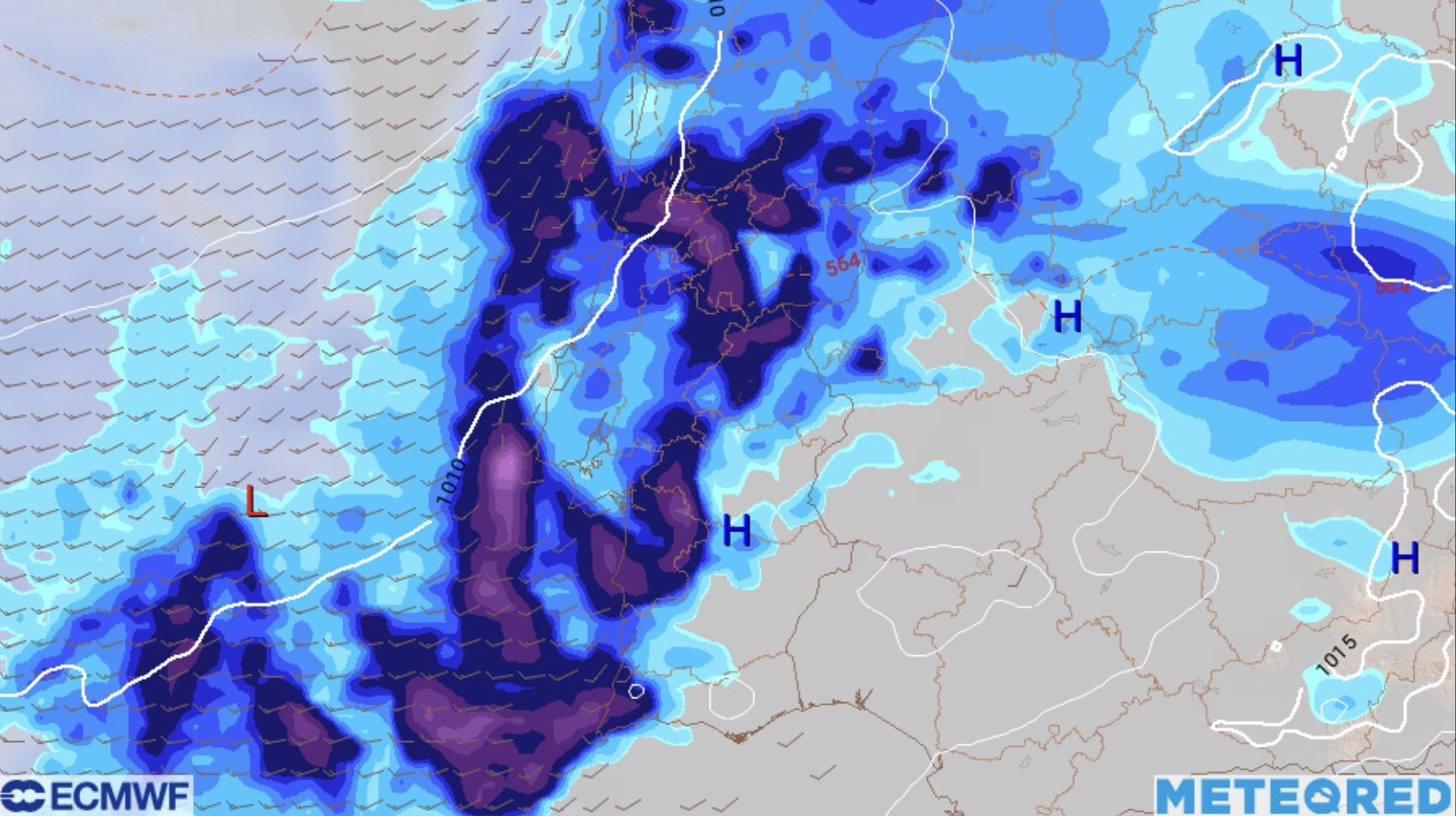
You can’t please everyone. There will be those who would like to extend the summer, but the normal thing is what will happen: a sharp drop of about 8 to 10ºC in thermometers, which will remain above normal for this time of year, with maximums of 24ºC/25ºC. According to European ECMMP models, rain could fall heavily over the next ten days, even in amounts that, due to the dry weather experienced and the current state of some crops, could cause considerable damage.
⛈️???? Excellent update of the European ECMWF model of the 12z…
????Up to 265 liters per m2 in 10 days.
Where are you supposed to sign? pic.twitter.com/HwQdfjM7rc— Márcio Santos – Meteorology and Environment (@MeteoTrasMontPT) October 9, 2023
Climate change is attributed to the approach of a cold, wet front from the Atlantic and two depressions. The first begins to enter the continent from the north this Friday morning and spreads throughout the country until the weekend, with associated strong winds (in the south perhaps only on Sunday and in Madeira on Monday). The Azores are already under a rain warning this Tuesday.
On Sunday, the first depression, centered in the Miño/Galicia area, is expected to cause the most intense and abundant rains, which will spread from north to south. There is even the possibility of an Atlantic river forming – a phenomenon in which it rains a lot, for a short time, in the same place, causing flooding – affecting parts of Portugal and Spain.
What is an atmospheric river ℹ️????? Here comes the phenomenon that could intensify the #rain In Portugal.
????️ Find out more in @alfredomgraca’s analysis and forecast. https://t.co/vnzr2YmN5H
—Weathered | Weather.pt (@MeteoredPT) October 10, 2023
#Rain on the way ????! The weather will finally change and, starting on Friday the 13th, two depressions and several fronts will leave widespread precipitation ????️.
The accumulation ???? will be significant in several regions of Portugal. A decrease in #temperatures and more intense wind. pic.twitter.com/4WC6Oe1y2O
—Weathered | Weather.pt (@MeteoredPT) October 10, 2023
#Last minute We will continue with stability and heat until the weekend. he #pillarbridge It will start at 30ºC throughout the country. A change will begin soon. Tomorrow the critical moment will arrive and on Sunday there will be a storm, with rain and thermal damage… pic.twitter.com/HRkLHBu3X3
— Eltiempo.es (@ElTiempoes) October 10, 2023
Thus, temperatures, which have already begun to drop and are below 30ºC – or around those values - since this Tuesday, will remain that way until Thursday, and then drop abruptly on Friday. That is, from one day to the next we stopped wearing suspenders or shorts, and instead we put on a sweater and maybe some boots on our feet. During the weekend the scenario will be the same, or even worse, so it is best not to make plans to go to the beach or anything outdoors.
Predictions of instability and lower temperatures continue at least until Thursday of next week, with the second storm and a carousel of Atlantic fronts.
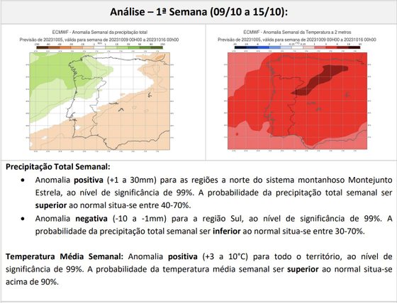
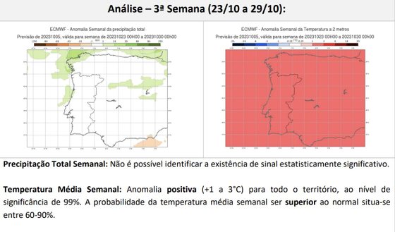
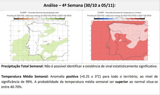
The IPMA has already made public its forecasts until November 5. Rainfall above normal for this time of year is expected until the 15th in the North and for the entire country until the 22nd. Temperatures will always be warmer than normal until early next month.

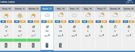
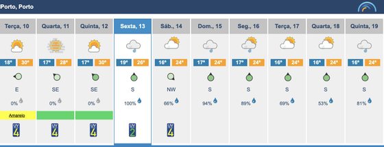
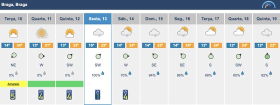
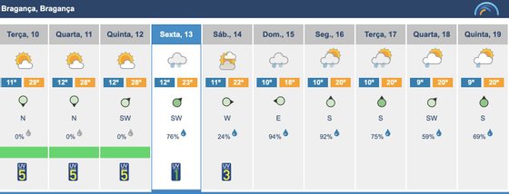
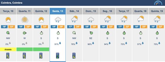
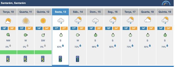
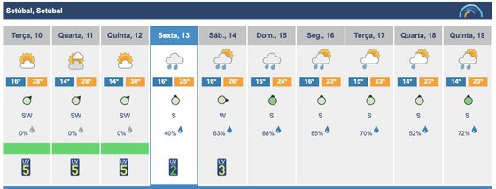
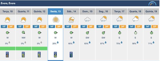
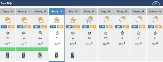
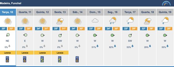
Until then, check the forecasts for the next few days in some cities.


Source: Observadora