The high temperatures felt in western Europe and the below-normal rainfall in almost all of Europe -except in Portugal and Spain, where it was no longer expected- explain the extremely high risk of fire in Portugal, Spain and Greecebut also the very high risk in Germany, Austria, Croatia, Slovakia, France, Hungary, Italy, Serbia and even Cyprus and Turkey, for this Thursday, according to the European Copernicus project.
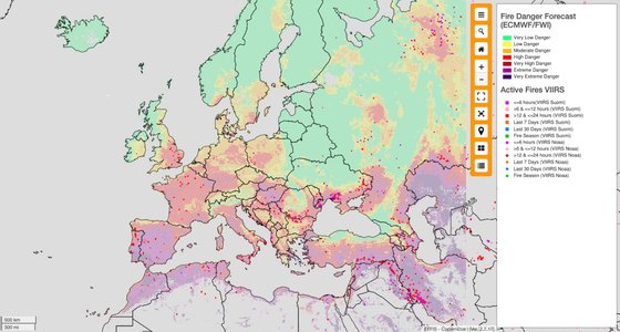
#EFFIS Fire Danger Forecast for July 14
????Very Extreme Hazard forecast in:
?????????#Spain: #Andalusia, #Estremadura & #CastillaYLeon regions
?????????#Portugal: #Algarve, #Alentejo, #Lisbon& Central Regions
?????????#Greece: #Attica region and islandsextreme danger in
?????????????????????????????????????????????????????? ???? ?????????????????????????????????????????????????????? ???? pic.twitter.com/fTQ7c4Xsff— Copernicus EMS (@CopernicusEMS) July 14, 2022
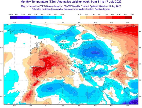
Iberian Peninsula, France and the United Kingdom with temperatures above average
This week, from July 11 to 17, temperatures in most of the Iberian Peninsula, France and the southeast of England are between six and ten degrees Celsius above average.

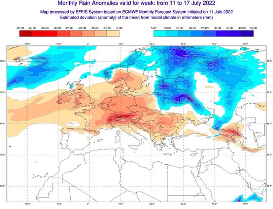
Central Europe has the largest reduction in rainfall
The region of Austria is the one that presents, in the week of July 11 to 17, the greatest reduction in rainfall (in millimeters) in relation to the average, but the decrease in the amount of rain extends from the United Kingdom to Germany. , France and Italy, from the Nordic countries to Greece.

Extremely high risk of fire in the Mediterranean region
The Iberian Peninsula, North Africa and most Mediterranean countries present extreme or very extreme fire risk. The risk is high in most of France and much of Germany, but also in England. Much of central and western Europe has at least a moderate fire risk.
The various points of the continent show the active fires.

Source: Observadora
