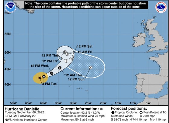
What was true yesterday is a lie today. Hurricane Danielle even changed course and will affect, although without a strong impact, the weather in the north of the Iberian Peninsula and the Azores. Although it does not cross the Azores Islands, its slow passage through the archipelago, in a north-northeast direction, will be felt both at sea level and with rain and strong wind, between Friday and Saturday. As of the weekend, already as an extratropical storm, its ‘leftovers’ will bring that rain and wind to the Portuguese coast, and the bad weather will be felt mainly in the north of the country.
#Last minute In the next few days, rains are expected in the northwest of the peninsula, with increased humidity in the middle layers thanks to the hurricane #danielle. From the end of the week it could reach the Peninsula (it was like a storm) and could bring rain to the Atlantic coast. pic.twitter.com/o6GLw2b6bD
– Eltiempo.es (@ElTiempoes) September 6, 2022
If you click on the video in this tweet, from the Spanish meteorology website El Tiempo, you will understand what Danielle’s walk is expected to be like from her current location, until the moment she arrives, like a simple storm, in the area. from Galicia. . The frontal system associated with it will affect time as it progresses (if it doesn’t decide to change its trajectory again, which is always possible).
the hurricane #danielle It will move in the next few hours to the northeast. You will find colder waters and unfavorable atmospheric conditions, which will weaken you. When it is close to Europe it will become a storm. Its effects, with high probability, will not be noticed in Spain. pic.twitter.com/ycS5Suftnq
— AEMET (@AEMET_Esp) September 5, 2022

The Danielle was sailing calmly off the coast of the Azores, heading northeast, heading for the United Kingdom, on Monday night. And in these cold Atlantic waters, she would most likely dissipate in the middle of the week, Wednesday or Thursday. But a sudden change of course caused her to veer to the southeast and set her on course to the north of the Iberian Peninsula. At the base of this change there may be a current of warm air or it may have been pushed by another hurricane that, at this time, began to move off the coast of North America, Earl.
☔????Hurricane Danielle changes course and goes back to Spain: this is how it could affect the peninsula when it arrives https://t.co/0BZ0Fps8in
— 20minutes.es (@20m) September 6, 2022
This change of direction makes all the difference. In the Azores there will be heavy rains and gusts of wind that can reach 60 km/h, according to the IPMA, on days 9 and 10. They will also be felt at the level of the waves and in the levels of precipitation and wind intensity from the end weekdays, especially in the north of the country.
As rains and an early autumn were already forecast, the only thing left is to hope that everything will be even more intense than expected. Because the hurricane, which always has a cyclical flow at medium and low levels, will push humid air towards the Peninsula, not only lowering temperatures, but also making the rainy front that would already affect us gain greater dimension.
That is to say: towards the north, and from Saturday, rains and strong winds are expected. Rain that should spread to the rest of the country in the next few days, although with less intensity, leaving only the Algarve dry. And that should stay until at least the middle of next week.
Source: Observadora
