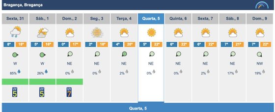
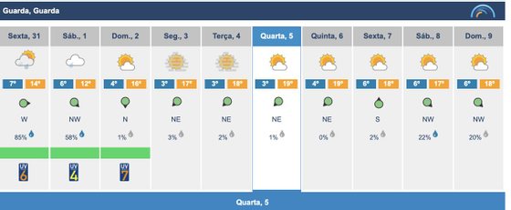
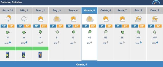
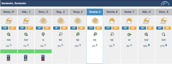
We are in roller coaster time modes. As quickly as the temperatures rise to the June values, they return to the normal values of March and April. This is how it will be this weekend, cooler and even with some rain in the North and Center. But shortly after the thermometers rise until Thursday even exceeding 30ºC. To go down again exactly on Good Friday and Easter Saturday and Sunday, where it can even rain and it will be cooler again. It is to tighten the belts, in this case those of the coats or trench coats.
????#Time: From April 04 to 09, dry weather and temperatures above normal for the time of year are expected. Possible weather change at the end of the week. T max from 20 to 24°C (north and central coast) and from 24 to 30°C (inland south) ????https://t.co/mlNwzoGU0B pic.twitter.com/i5d7LLAdea
—IPMA (@ipma_pt) March 31, 2023
Storm Mathis, now south of the British Isles, won’t affect us directly, but (and there’s always a but to these things) its remnants will. Meteorologically speaking, the passage of a cold front associated with the depression that the French called Mathis began to cross Portugal on Thursday night, causing light rains in the North and Center regions and also an increase in maritime agitation (there are alerts, see the IPMA map), advising against walks by the sea. This annoying drizzle will continue until early Sunday over the Tagus. In the south, although it should not rain, the sky should remain cloudy and it will be difficult to see the sun. Throughout the country there will be a drop in maximum temperatures and the nights will also be much colder.
Media Time
Attention to Meteorological Warnings for the Continent:
Maritime Unrest – Yellow [ 31 Mar 06:00 – 31 Mar 18:00 ]
West-northwest waves of 4 to 5 meters.https://t.co/hfv28QDh63 pic.twitter.com/AuIjps41Jx—IPMA (@ipma_pt) March 31, 2023
This is how it can be seen from the satellite #borrascamathis ????, the 13th high-impact of the season and nominated a few hours ago by @meteofrance.
It will leave very intense winds in the northern half of #Galicia and an important maritime storm???? on the northern shores. pic.twitter.com/7uVZKpAI76
— Meteorite | weather.com (@MeteoredES) March 30, 2023
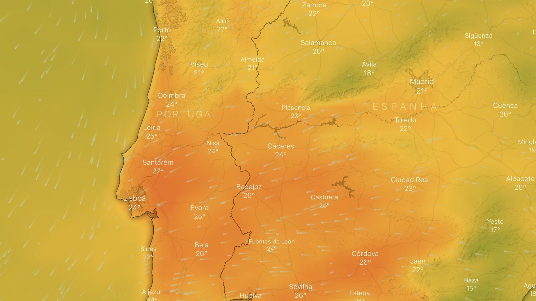
After these days with a few drops of rain and a lot of clouds, everything changes. And the heat returns with force. The fault lies with an anticyclonic region that will extend from Scandinavia to the Azores, which will form a kind of wall, blocking the passage of frontal systems that bring rain or cold.
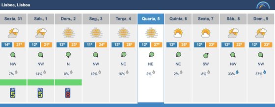
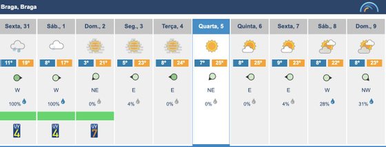
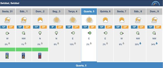
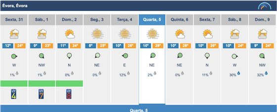
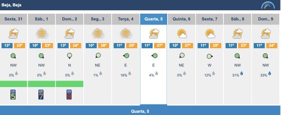
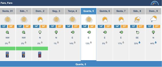
The result of this is that between 26ºC and 27ºC are forecast for Lisbon between Tuesday and Thursday, Santarém will oscillate between 28ºC and 30ºC, Évora and Beja will also reach 28ºC, Braga can reach 24ºC, the same temperature forecast for the Algarve. In summary, maximum temperature values are expected between 20 and 24 °C on the coast and interior North and Center and between 24 and 30 °C in the interior of the South region. Well above normal for this time of year, as happened last week, not only in Portugal, but also in Spain and the south of France, where temperatures exceeded 30ºC.
♨️ HEAT IN MARCH
Maximum temperatures observed yesterday on the official IPMA network:
↗️ Santarem: 31.5°C
↗️ Alvalade: 30.8°C
↗️ Alcácer do Sal: 30.7°C
↗️ Live: 30.7°C
↗️ Coruche: 30.6°C
↗️ Pinion: 30.3°C
These are values well above the averages for the period. pic.twitter.com/v9AXkKv3Tp— Meteo Tras-os-Montes – Portugal (@MeteoTrasMontPT) March 29, 2023
Intense heat is breaking March records in Morocco and southwestern Europe.
The hottest day in March for many weather stations, including almost 40°C in Agadir, Morocco, with many stations exceeding 30°C in Spain, Portugal and southern France. pic.twitter.com/3WN8UbBBOa
—Scott Duncan (@ScottDuncanWX) March 29, 2023
The thermal amplitudes will remain very high, since the nights will remain cold, between 3 and 7°C in the North and Central interior and between 8 and 13°C in the rest of the country. In Santarém, for example, it will be 11ºC at night and 30ºC during the day, a variation of 19ºC, one of those that colds love.
After several days in a “straight line”, the polar jet is expected to undulate 〰️ in the #Easter ✝️, which would result in the arrival of cold air ????️???? at lower latitudes.
In high layers, but also on the surface. Effects on #Portugal? Still to find out ???????.
????️ https://t.co/SJhA0tf8Zb pic.twitter.com/4Qm9QyPmrI
— Meteorite | Tempo.pt (@MeteoredPT) March 29, 2023
#Last minute This first weekend of the #Easter We will have some precipitation in the northern half, as well as a temperature drop that will bring a somewhat wintery environment. Next week will be dry, which could increase the chance of rain over the weekend. pic.twitter.com/tEi2ON1z3O
– Eltiempo.es (@ElTiempoes) March 30, 2023
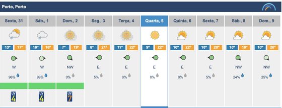
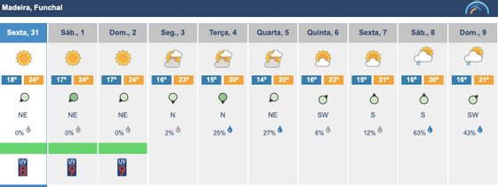
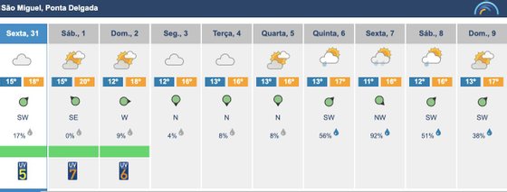
But then, as Easter approaches, starting Thursday the 5th, a depression region is expected to form between the Madeira archipelago and North Africa, which should influence the continent’s climate at the end of week. It is another ride on the roller coaster, with a drop that should be between 3 and 4ºC. And from summer we return to spring again, with highs of 24ºC in the hottest cities and 19ºC in the coolest ones, with the possibility of it raining again, this time in the south (to compensate).
Source: Observadora
